Did you ever wonder where the web trafic really flow to reach the web servers, and who own the network equipment it is flowing through? It is possible to get a glimpse of this from using traceroute, but it is hard to find all the details. Many years ago, I wrote a system to map the Norwegian Internet (trying to figure out if our plans for a network game service would get low enough latency, and who we needed to talk to about setting up game servers close to the users. Back then I used traceroute output from many locations (I asked my friends to run a script and send me their traceroute output) to create the graph and the map. The output from traceroute typically look like this:
traceroute to www.stortinget.no (85.88.67.10), 30 hops max, 60 byte packets
 1  uio-gw10.uio.no (129.240.202.1)  0.447 ms  0.486 ms  0.621 ms
 2  uio-gw8.uio.no (129.240.24.229)  0.467 ms  0.578 ms  0.675 ms
 3  oslo-gw1.uninett.no (128.39.65.17)  0.385 ms  0.373 ms  0.358 ms
 4  te3-1-2.br1.fn3.as2116.net (193.156.90.3)  1.174 ms  1.172 ms  1.153 ms
 5  he16-1-1.cr1.san110.as2116.net (195.0.244.234)  2.627 ms he16-1-1.cr2.oslosda310.as2116.net (195.0.244.48)  3.172 ms he16-1-1.cr1.san110.as2116.net (195.0.244.234)  2.857 ms
 6  ae1.ar8.oslosda310.as2116.net (195.0.242.39)  0.662 ms  0.637 ms ae0.ar8.oslosda310.as2116.net (195.0.242.23)  0.622 ms
 7  89.191.10.146 (89.191.10.146)  0.931 ms  0.917 ms  0.955 ms
 8  * * *
 9  * * *
[...]
This show the DNS names and IP addresses of (at least some of the) network equipment involved in getting the data traffic from me to the www.stortinget.no server, and how long it took in milliseconds for a package to reach the equipment and return to me. Three packages are sent, and some times the packages do not follow the same path. This is shown for hop 5, where three different IP addresses replied to the traceroute request.
There are many ways to measure trace routes. Other good traceroute implementations I use are traceroute (using ICMP packages) mtr (can do both ICMP, UDP and TCP) and scapy (python library with ICMP, UDP, TCP traceroute and a lot of other capabilities). All of them are easily available in Debian.
This time around, I wanted to know the geographic location of different route points, to visualize how visiting a web page spread information about the visit to a lot of servers around the globe. The background is that a web site today often will ask the browser to get from many servers the parts (for example HTML, JSON, fonts, JavaScript, CSS, video) required to display the content. This will leak information about the visit to those controlling these servers and anyone able to peek at the data traffic passing by (like your ISP, the ISPs backbone provider, FRA, GCHQ, NSA and others).
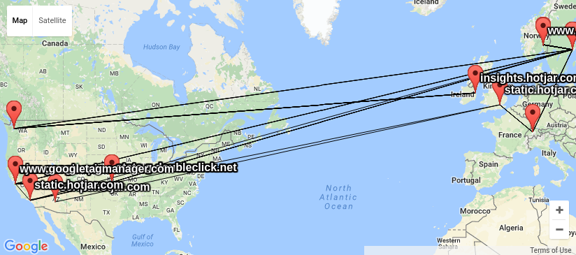
Lets pick an example, the Norwegian parliament web site www.stortinget.no. It is read daily by all members of parliament and their staff, as well as political journalists, activits and many other citizens of Norway. A visit to the www.stortinget.no web site will ask your browser to contact 8 other servers: ajax.googleapis.com, insights.hotjar.com, script.hotjar.com, static.hotjar.com, stats.g.doubleclick.net, www.google-analytics.com, www.googletagmanager.com and www.netigate.se. I extracted this by asking PhantomJS to visit the Stortinget web page and tell me all the URLs PhantomJS downloaded to render the page (in HAR format using their netsniff example. I am very grateful to Gorm for showing me how to do this). My goal is to visualize network traces to all IP addresses behind these DNS names, do show where visitors personal information is spread when visiting the page.
When I had a look around for options, I could not find any good free software tools to do this, and decided I needed my own traceroute wrapper outputting KML based on locations looked up using GeoIP. KML is easy to work with and easy to generate, and understood by several of the GIS tools I have available. I got good help from by NUUG colleague Anders Einar with this, and the result can be seen in my kmltraceroute git repository. Unfortunately, the quality of the free GeoIP databases I could find (and the for-pay databases my friends had access to) is not up to the task. The IP addresses of central Internet infrastructure would typically be placed near the controlling companies main office, and not where the router is really located, as you can see from the KML file I created using the GeoLite City dataset from MaxMind.

I also had a look at the visual traceroute graph created by the scrapy project, showing IP network ownership (aka AS owner) for the IP address in question. The graph display a lot of useful information about the traceroute in SVG format, and give a good indication on who control the network equipment involved, but it do not include geolocation. This graph make it possible to see the information is made available at least for UNINETT, Catchcom, Stortinget, Nordunet, Google, Amazon, Telia, Level 3 Communications and NetDNA.
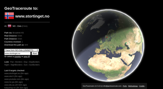
In the process, I came across the web service GeoTraceroute by Salim Gasmi. Its methology of combining guesses based on DNS names, various location databases and finally use latecy times to rule out candidate locations seemed to do a very good job of guessing correct geolocation. But it could only do one trace at the time, did not have a sensor in Norway and did not make the geolocations easily available for postprocessing. So I contacted the developer and asked if he would be willing to share the code (he refused until he had time to clean it up), but he was interested in providing the geolocations in a machine readable format, and willing to set up a sensor in Norway. So since yesterday, it is possible to run traces from Norway in this service thanks to a sensor node set up by the NUUG assosiation, and get the trace in KML format for further processing.
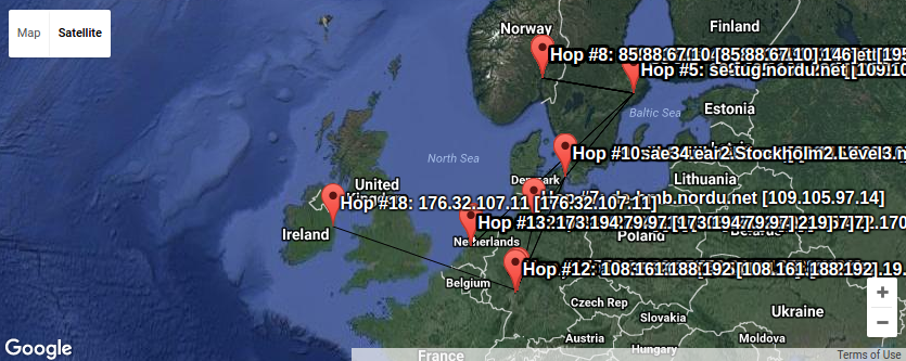
Here we can see a lot of trafic passes Sweden on its way to Denmark, Germany, Holland and Ireland. Plenty of places where the Snowden confirmations verified the traffic is read by various actors without your best interest as their top priority.
Combining KML files is trivial using a text editor, so I could loop over all the hosts behind the urls imported by www.stortinget.no and ask for the KML file from GeoTraceroute, and create a combined KML file with all the traces (unfortunately only one of the IP addresses behind the DNS name is traced this time. To get them all, one would have to request traces using IP number instead of DNS names from GeoTraceroute). That might be the next step in this project.
Armed with these tools, I find it a lot easier to figure out where the IP traffic moves and who control the boxes involved in moving it. And every time the link crosses for example the Swedish border, we can be sure Swedish Signal Intelligence (FRA) is listening, as GCHQ do in Britain and NSA in USA and cables around the globe. (Hm, what should we tell them? :) Keep that in mind if you ever send anything unencrypted over the Internet.
PS: KML files are drawn using the KML viewer from Ivan Rublev, as it was less cluttered than the local Linux application Marble. There are heaps of other options too.
As usual, if you use Bitcoin and want to show your support of my activities, please send Bitcoin donations to my address 15oWEoG9dUPovwmUL9KWAnYRtNJEkP1u1b.